The Ice Age and Origins of the Humber Watershed
Toronto, Ontario
Toronto, Ontario
Introduction
Overview of the
Humber River
Global and Continental Glaciation
Land Form Development in North America
Geological History
of the Great Lakes
Development of the
Oak Ridges Moraine
Geology of the
Humber River Watershed
Ecology
Early Inhabitants
Maps of the
Humber River Watershed
Photo Gallery Humber River Watershed
Overview of Geological Origins of the Humber River
Part III
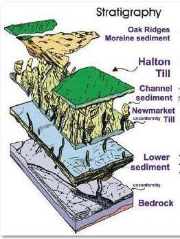
Stratigraphic framework - Southern Ontario and Oak Ridges Moraine Area
(As below and oldest unit first):
1. Canadian Shield (Pre Cambrian period - older than 550 million years)
 2. Paleozoic Bedrock (550 to 350 million years BP)
Simcoe Group Limestone
Georgian Bay Shale/Blue Mountain Shale
Queenston Shale
Cataract and Clinton Group Sandstones and Shales
Amabel/Lockport Dolostone
3. Regional Unconformity ?The Big Gap? (350 million to 135,000 years BP)
4. Pleistocene Sediments (135,000 to 10,000 years BP)
York Till (or equivalent)
Don Formation (or equivalent)
Scarborough Formation (or equivalent)
Sunnybrook Drift (or equivalent)
Thorncliffe Formation (or equivalent)
Newmarket Till (also referred to as the Northern Till)
Regional unconformity (channel infill deposits) (after about 20,000 years BP)
Oak Ridges Moraine (about 13,300 years BP)
Halton/Kettleby Till (or equivalents, including Wentworth Till)
Glaciolacustrine Deposits (sand, silt and clay) (about 12,500 years BP)
5. Recent fluvial deposits - Halocene Period (sands, silts, and clay along streams)
